Class 11 Geography Notes Chapter 3 Drainage System
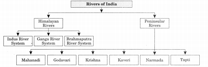
On the basis of discharge of water (orientations to the sea), it may be grouped into:
- The Arabian Sea drainage; and
- The Bay of Bengal drainage.
Nearly 77 per cent of the drainage area consisting of the Ganga, the Brahmaputra, the Mahanadi, the Krishna, etc. are oriented towards the Bay of Bengal while 23 per cent comprising the Indus, the Narmada, the Tapi, the Mahi and the Periyar systems discharge their waters in the Arabian Sea.
On the basis of the size of the watershed, the drainage basins of India are grouped into three categories:
- Major river basins with more than 20,000 sq. km of catchment area. It includes 14 drainage basins such as the Ganga, the Brahmaputra, the Krishna, the Tapi, the Narmada, the Mahi, the Penner, the Sabarmati, the Barak, etc.
- Medium river basins with catchment area between 2,000-20,000 sq. km incorporating 44 river basins such as the Kalindi, the Periyar, the Meghna, etc.
Minor river basins with catchment area of less than 2,000 sq. km include fairly good number of rivers flowing in the area of low rainfall.
The Indus System is one of the largest river basins of the world, covering an area of 11,65,000 sq. km (in India it is 321, 289 sq. km) and a total length of 2,880 km and in India its length is 1,114 km.
The Jhelum, an important tributary of the Indus, rises from a spring at Verinag situated at the foot of the Pir Panjal in the south-eastern part of the valley of Kashmir. It flows through Srinagar and the Wular lake before entering Pakistan through a deep narrow gorge. It joins the Chenab near Jhang in Pakistan.
The Chenab is the largest tributary of the Indus. It is formed by two streams, the Chandra and the Bhaga, which join at Tandi near Keylong in Himachal Pradesh. Hence, it is also known as Chandrabhaga.
The Ravi is another important tributary of the Indus. It rises west of the Rohtang pass in the Kullu hills of Himachal Pradesh and flows through the Chamba valley of the state.
The Beas is another important tributary of the Indus, originating from the Beas Kund near the Rohtang Pass at an elevation of 4,000 m above the mean sea level. The river flows through the Kullu valley and forms gorges at Kati and Largi in the Dhaoladhar range.
Satluj river flows almost parallel to the Indus for about 400 km before entering India, and comes out of a gorge at Rupar. It passes through the Shipki La on the Himalayan ranges and enters the Punjab plains. It is an antecedent river. It is a very important tributary as it feeds the canal system of the Bhakra Nangal project.
The Ganga System rises in the Gangotri glacier near Gaumukh (3,900 m) in the Uttarkashi district of Uttarakhand. Here, it is known as the Bhagirathi. It cuts through the Central and the Lesser Himalayas in narrow gorges. At Devprayag, the Bhagirathi meets the Alaknanda; hereafter, it is known as the Ganga. The Alaknanda has its source in the Satopanth glacier above Badrinath.
The Alaknanda consists of the Dhauli and the Vishnu Ganga which meet at Joshimath or Vishnu Prayag. The other tributaries of Alaknanda such as the Pindar joins it at Kama Prayag while Mandakini or Kali Ganga meets it at Rudra Prayag.
The Ganga river has a length of 2,525 km. It is shared by Uttarakhand (110 km) and Uttar Pradesh (1,450 km), Bihar (445 km) and West Bengal (520 km).
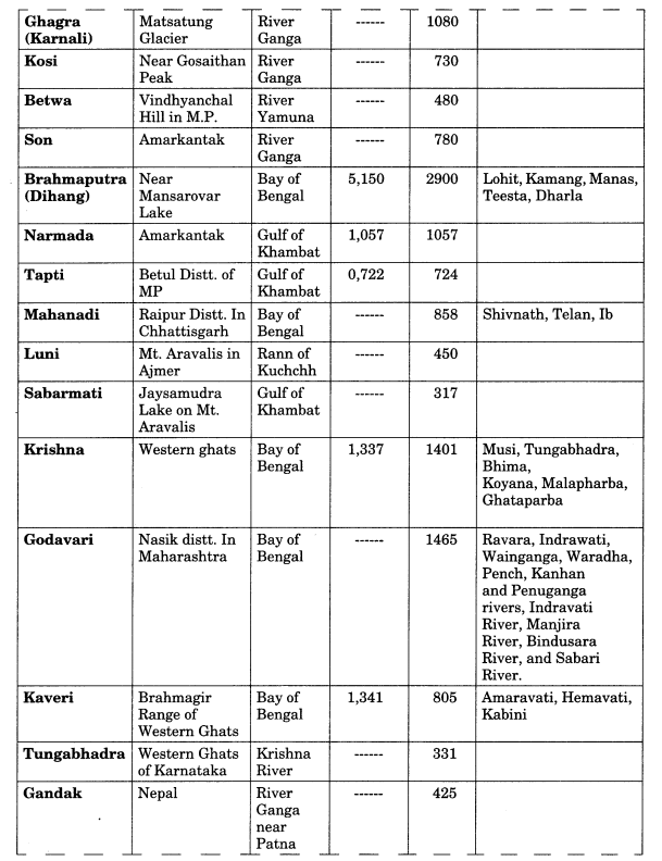
The Ganga basin covers about 8.6 lakh sq. km area in India alone. The Ganga river system is the largest in India having a number of perennial and non-perennial rivers originating in the Himalayas in the north and the Peninsula in the south, respectively. The Son is its major right bank tributary. The important left bank tributaries are the Ramganga, the Gomati, the Ghaghara, the Gandak, the Kosi and the Mahananda.
The Yamuna is the western most and the longest tributary of the Ganga. It has its source in the Yamunotri glacier on the western slopes of Banderpunch range (6,316 km). It joins the Ganga at Prayag in Allahabad. It is joined by the Chambal, the Sind, the Betwa and the Ken on its right bank which originates from the Peninsular plateau while the Hindan, the Rind, the Sengar, the Varuna, etc. join it on its left bank.
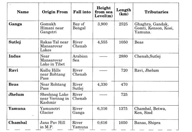
The Chambal rises near Mhow in the Malwa plateau of Madhya Pradesh and flows northwards through a gorge up wards of Kota in Rajasthan, where the Gandhisagar dam has been constructed. From Kota, it traverses down to Bundi, Sawai Madhopur and Dholpur, and finally joins the Yamuna.
The Gandak comprises two streams, namely Kaligandak and Trishulganga. It rises in the Nepal Himalayas between the Dhaulagiri and Mount Everest and drains the central part of Nepal.
The Brahmaputra is one of the largest rivers of the world. It has its origin in the Chemayungdung glacier of the Kailash range near the Mansarovar lake.
The Brahmaputra receives numerous tributaries in its 750 km long journey through the Assam valley. Its major left bank tributaries are the Burhi Dihing and Dhansari (South) whereas the important right bank tributaries are the Subansiri, Kameng, Manas and Sankosh.. The Subansiri which has its origin in Tibet, is an antecedent river.
The Peninsular drainage system is older than the Himalayan one. This is evident from the broad, largely-graded shallow valleys, and the maturity of the rivers.
Most of the major Peninsular rivers except Narmada and Tapi flow from west to east. The Chambal, the Sind, the Betwa, the Ken, the Son, originating in the northern part of the Peninsula belong to the Ganga river system. The other major river systems of the Peninsular drainage are – the Mahanadi, the Godavari, the Krishna and the Kaveri. Peninsular rivers are characterised by fixed course, absence of meanders and non- perennial flow of water.
Three major geological events in the distant past have shaped the present drainage systems of Peninsular India:
- Subsidence of the western flank of the Peninsula leading to its submergence below the sea during the early tertiary period.
- Upheaval of the Himalayas when the northern flank of the Peninsular block was subjected to subsidence and the consequent trough faulting.
- Slight tilting of the Peninsular block from north-west to the south-eastern direction gave orientation to the entire drainage system towards the Bay of Bengal during the same period.
There are some problems in river water usage. Some of these are:
- No availability in sufficient quantity.
- River water pollution.
- Load of silt in the river water.
- Uneven seasonal flow of water.
- River water disputes between states.
- Shrinking of channels due to the extension of settlements towards the thalweg.
Class 11 Geography Notes Chapter 3 Important Terms:
- Drainage: The flow of water through well-defined channels is known as ‘drainage.’
- Drainage System: The network of drainage channels is called a ‘drainage system’.
- Dendritic Drainage System: The drainage pattern resembling the branches of a tree is known as “dendritic” the examples of which are the rivers of northern plain.
- Radial Drainage System: When the rivers originate from a hill and flow in all directions, the drainage pattern is known as ‘radial’. The rivers originating from the Amarkantak range present a good example of it.
- Trellis: When the primary tributaries of rivers flow parallel to each other and secondary tributaries join them at right angles, the pattern is known as ‘trellis’.
- Centripetal Drainage System: When the rivers discharge their waters from all directions in a lake or depression, the pattern is known as ‘centripetal’.
- Catchment area: A river drains the water collected from a specific area, which is called its ‘catchment area’.
- Drainage Basin: An area drained by a river and its tributaries is called a drainage basin.
- Watershed: The boundary line separating one drainage basin from the other is known as the watershed.
- Sorrow of Bengal: River Damodar is also known as the ‘Sorrow of Bengal’ as it changes its course very frequently and causes floods in Bihar.
- Sorrow of Bihar: River Kosi is called Sorrow of Bihar.
- River System: A river or a river system is a body of water flowing in a channel through the surface of the earth. It consists of four important parts: river course, river source, tributaries and river mouth.
- River Source: A place at which begins or originates. This is usually found in mountainous areas. The source may be melting snow from the top of a mountain on a lake with stream flowing out of it. A river flow downhill from its source due to the force of gravity
- River Course: The path on which the river flows along.
- Singi Khamban or Lion’s mouth: Kailash Mountain range is known as ‘Singi Khamban; or Lion’s mouth in Tibet.
- Regime: The pattern of flow of water in a river channel over a year is known as its regime.
- Cusecs: It means cubic feet per second.
- Cumecs: It stands for cubic metres per second.
Class 11 Geography Notes
<!–
–>