Class 11 Geography Notes Chapter 2 Structure and Physiography
These geological regions broadly follow the physical features:
- The Peninsular Block
- The Himalayas and other Peninsular Mountains
- Indo-Ganga-Brahmaputra Plain.
The northern boundary of the Peninsular Block may be taken as an irregular line running from Kachchh along the western flank of the Aravali Range near Delhi and then roughly parallel to the Yamuna and the Ganga as far as the Rajmahai Hills and the Ganga delta. Apart from these, the Karbi Anglong and the Meghalaya Plateau in the north-east and Rajasthan in the west are also extensions of this block.
The Peninsula is formed essentially by a great complex of very ancient gneisses and granites, which constitutes a major part of it. The rift valleys of the Narmada, the Tapi and the Mahanadi and the Satpura block mountains are some examples of it. The Peninsula mostly consists of relict and residual mountains like the Aravali hills, the Nallamala hills, the Javadi hills, the Veliconda hills, the Palkonda range and the Mahendragiri hills, etc.
Most of the east flowing rivers form deltas before entering into the Bay of Bengal. The deltas formed by the Mahanadi, the Krishna, the Kaveri and the Godavari are important examples.
The Himalayas along with other Peninsular mountains are young, weak and flexible in their geological structure unlike the rigid and stable Peninsular Block. Consequently, they are still subjected to the interplay of exogenic and endogenic forces, resulting in the development of faults, folds and thrust plains.
The third geological division of India comprises the plains formed by the river Indus, the Ganga and the Brahmaputra. Originally, it was a geo-synclinal depression which attained its maximum development during the third phase of the Himalayan mountain formation approximately about 64 million years ago. Since then, it has been gradually filled by the sediments brought by the Himalayan and Peninsular rivers. Average depth of alluvial deposits in these plains ranges from 1,000-2,000 m.
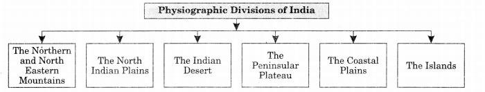
India can be divided into the following physio-graphic divisions:
- The Northern and North-eastern Mountains
- The Northern Plain
- The Peninsular Plateau
- The Indian Desert
- The Coastal Plains
- The Islands.
The North and North-eastern Mountains consist of the Himalayas and the North-eastern hills. The Himalayas consist of a series of parallel mountain ranges. Some of the important ranges are the Greater Himalayan range, which includes the Great Himalayas and the Trans-Himalayan range, the Middle Himalayas and the Shiwalik.
The approximate length of the Great Himalayan range, also known as the central axial range, is 2,500 km from east to west, and their width varies between 160-400 km from north to south.
On the basis of relief, alignment of ranges and other geomorphological features, the Himalayas can be divided into the following sub-divisions:
- Kashmir or North-western Himalayas.
- Himachal and Uttaranchal Himalayas.
- Darjeeling and Sikkim Himalayas.
- Arunachal Himalayas.
- Eastern Hills and Mountains.
Kashmir or North-western Himalayas comprise a series of ranges such as the Karakoram, Ladakh, Zaskar and Pir Panjal. The north-eastern part of the Kashmir Himalayas is a cold desert, which lies between the Greater Himalayas and the Karakoram ranges.
The word shiwalik has its origin in the geological formation found in and around a place called Sivawala near Dehra Dun which was once a headquarter of the Imperial Survey and which subsequently established its permanent headquarters at Dehra Dun.
The Himachal and Uttarakhand Himalayas lies approximately between the Ravi in the west and the Kali (a tributary of Ghaghara) in the east. In this section of Lesser Himalayas, the altitude between 1,000-2,000 m specially attracted to the British colonial administration, and subsequently, some of the important hill stations such as Dharamshala, Mussoorie, Shimla, Kaosani and the cantonment towns and health resorts such as Shimla, Mussoorie, Kasauli, Almora, Lansdowne and Ranikhet, etc. were developed in this region.
The two distinguishing features of this region from the point of view of physiography are the ‘Shiwalik’ and ‘Dun formations’, Some important duns located in this region are the Chandigarh – Kalka Dun, Nalagarh Dun, Dehra Dun, Harike Dun and the Kota Dun.
In the Great Himalayan range, the valleys are mostly inhabited by the Bhotia’s. These are nomadic groups who migrate to ‘Bugyals’ (the summer glass lands in the higher reaches) during summer months and return to the valleys during winters. The famous ‘Valley of flowers’ is also situated in this region. The places of pilgrimage such as the Gangotri, Yamunotri, Kedarnath, Badrinath and Hemkund Sahib are also situated in this part.
Sikkim and Darjeeling Himalayas are also known for their scenic beauty and rich flora and fauna, particularly various types of orchids.
An important aspect of the Arunachal Himalayas is the numerous ethnic tribal community inhabiting in these areas. Some of the prominent ones from west to east are the Monpa, Daffla, Abor, Mishmi, Nishi and the Nagas. Most of these communities practise Jhumming. It is also known as shifting or slash and burn cultivation. This region is rich in biodiversity which has been preserved by the indigenous communities. Due to rugged topography, the inter-valley transportation linkages are nominal. Hence, most of the interactions are carried through the duar region along the Arunachal-Assam border.
The Eastern Hills and Mountains are having their general alignment from the north to the south direction. They are known by different local names. In the north, they are known as Patkai Bum, Naga hills, the Manipur hills and in the south as Mizo or Lushai hills. These are low hills, inhabited by numerous tribal groups practising Jhum cultivation.
The northern plains are formed by the alluvial deposits broiight by the rivers – the Indus, the Ganga and the Brahmaputra. These plains extend approximately 3,200 km from the east to the west. The average width of these plains varies between 150-300 km. The maximum depth of alluvium deposits varies between 1,000-2,000 m. From the north to the south, these can be divided into three major zones: the Bhabar, the Tarai and the alluvial plains. The alluvial plains can be further divided into the Khadar and the Bhangar.
Bhabar is a narrow belt ranging between 8-10 km parallel to the Shiwalik foothills at the break-up of the slope. As a result of this, the streams and rivers coming from the mountains deposit heavy materials of rocks and boulders, and at times, disappear in this zone. South of the Bhabar is the Tarai belt, with an approximate width of 10-20 km where most of the streams and rivers re-emerge without having any properly demarcated channel, thereby, creating marshy and swampy conditions known as the Tarai.
Northern Plains is a featureless plain with a general elevation of 50-150 m above the mean sea level. The states of Haryana and Delhi form a water divide between the Indus and the Ganga river systems.
Rising from the height of 150 m above the river plains up to an elevation of 600-900 m is the irregular triangle known as the Peninsular plateau. Delhi ridge in the northwest, (extension of Aravalis), the Rajmahal hills in the east, Gir range in the west and the Cardamom hills in the south constitute the outer extent of the Peninsular plateau. However, an extension of this is also seen in the northeast, in the form of Shillong and Karbi-Anglong plateau. The Peninsular India is made up of a series of patland plateaus such as the Hazaribagh plateau, the Palamu plateau, the Ranchi plateau, the Malwa plateau, the Coimbatore plateau and the Karnataka plateau, etc.
On the basis of the prominent relief features, the Peninsular plateau can be divided into three broad groups:
- The Deccan Plateau
- The Central Highlands
- The North-eastern Plateau.
The Deccan Plateau is bordered by the Western Ghats in the west, Eastern Ghats in the east and the Satpura, Maikal range and Mahadeo hills in the north. Western Ghats are locally known by different names such as Sahyadri in Maharashtra, Nilgiri hills in Karnataka and Tamil Nadu and Anaimalai hills and Cardamom hills in Kerala. Western Ghats are comparatively higher in elevation and more continuous than the Eastern Ghats. Their average elevation is about 1,500 m with the height increasing from north to south. ‘Anaimudi (2,695 m), the highest peak of Peninsular plateau is located on the Anaimalai hills of the Western Ghats followed by Dodabetta (2,637 m) on the Nilgiri hills.
Some of the important ranges in Eastern Ghats include the Javadi hills, the Palconda . range, the Nallamala hills, the Mahendragiri hills, etc.
The Meghalaya plateau is further sub-divided into three:
- The Garo Hills
- The Khasi Hills
- The Jaintia Hills
These are named after the tribal groups inhabiting this region. An extension of this is also seen in the Karbi Anglong hills of Assam.
To the north-west of the Aravali hills lies the Great Indian Desert. It is a land of undulating topography dotted with longitudinal dunes and barchans. This region receives low rainfall below 150 mm per year; hence, it has arid climate with low vegetation cover.
On the basis of the location and active geomorphological processes, it can be broadly divided into two:
- The western coastal plains
- The eastern coastal plains.
There are two major island groups in India – one in the Bay of Bengal and the other in the Arabian Sea. The Bay of Bengal island groups consist of about 572 islands/islets. These are situated roughly between 6°N-14°N and 92°E -94°E. The two principal groups of islets include the Ritchie’s archipelago and the Labrynth island.
Some important mountain peaks in Andaman and Nicobar islands are Saddle peak (North Andaman – 738 m), Mount Diavolo (Middle Andaman – 515 m), Mount Koyob (South Andaman – 460 m) and Mount Thuiller (Great Nicobar – 642 m). These islands are located at a distance of 280 km-480 km off the Kerala coast. The entire island group.is built of coral deposits. There are approximately 36 islands of which 11 are inhabited. Minicoy is the largest island with an area of 453 sq. km.
Class 11 Geography Notes Chapter 2 Important Terms:
- Physiography: ‘Physiography’ of an area is the outcome of structure, process and the stage of development.
- Central axial range: The approximate length of the Great Himalayan range is known as the central axial range. It is 2,500 km from east to west
- Indo-Ganga-Brahmaputra Plain: It is a geological division of India that comprises the plains formed by the river Indus, the Ganga and the Brahmaputra.
- Bhabar: Bhabar is a narrow belt ranging between 8-10 km parallel to the Shiwalik foothills at the break-up of the slope. As a result of this, the streams and rivers coming from the mountains deposit heavy materials of rocks and boulders, and at times, disappear in this zone.
- Kashmir or North-western Himalayas: It comprise a series of ranges such as the Karakoram, Ladakh, Zaskar and Pir Panjal. The north-eastern part of the Kashmir Himalayas is a cold desert, which lies between the Greater Himalayas and the Karakoram ranges.
- Duns: The southernmost part of this region consists of longitudinal valleys. These are known as ‘duns’. Jammu dun and Pathankot dun are important examples.
- Tarai: South of the Bhabar is the Tarai belt, with an approximate width of 10-20 km where most of the streams and rivers re-emerge without having any properly demarcated channel, thereby, creating marshy and swampy conditions known as the Tarai.
- Bhangar: The south of Tarai is a belt consisting of old alluvial deposits which is known as the Bhangar.
- Khadar: The south of Tarai is a belt consisting of new alluvial deposits is known as Khadar.
- Dhaoladhar: The Lesser Himalayas is locally known as Dhaoladhar in Himachal Pradesh.
- Nagtibha: The Lesser Himalayas are called Nagtibha in Uttarakhand.
- Ten Degree Channel: The Andaman in the north and the Nicobar in the south are separated by a water body. It is called the Ten degree channel.
- The Peninsular Plateau: Rising from the height of 150 m above the river plains upto an elevation of 600-900 m is the irregular triangle known as the Peninsular plateau.
- The Central Highlands: They are bounded to the west by the Aravali range.
- Satpura Range: The Satpura range is formed by a series of scarped plateaus on the south, generally at an elevation varying between 600-900 m above the mean sea level.
- Barchans: The extension of the Peninsular plateau can be seen as far as Jaisalmer in the West, where it has been covered by the longitudinal sand ridges and crescent-shaped sand dunes. These are called barchans.
- Loktak: The physiography of Manipur is unique by the presence of a large lake known as ‘Loktak’.
- Molassis Basin: Mizoram is also known as the ‘Molassis basin’ which is made up of soft unconsolidated deposits.
- Kayals: Boatwaters are called kayals in Kerala.
- Karewas: Karewas are the thick deposits of glacial clay and other materials embedded with moraines.
- Dhaya: Bangal is called dhaya in Punjab.
- Bate: Khadar is called bate in Punjab.
Class 11 Geography Notes
<!–
–>